City of Sydney
- GPO Box 1591Sydney 2001
- 02 9265 9333
- [email protected]
One of the City of Sydney’s biggest urban development projects.
Located in Erskineville and bordering Alexandria, the 17-hectare site is a new residential neighbourhood with local shops and cafes.
The site is bounded by Ashmore Street, Mitchell Road, Coulson Street and the Bankstown railway line.
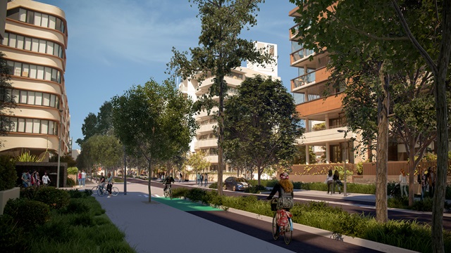
By 2025 Ashmore will have around 6,000 residents. The redevelopment includes new streets, some with separated bicycle lanes, a large central park and systems to manage stormwater.
Terraces, apartments, and live-work accommodation have been designed to meet the housing needs of 21st century living.

We support sustainable development that meets the needs of a growing population and respects the character of surrounding suburbs.
The urban design controls for Ashmore were developed in consultation with the community and landowners. The current planning controls for the site are the Sydney Local Environment Plan (LEP) 2012 and the Sydney Development Control Plan 2012 (Sydney DCP).
Terraces, townhouses and apartments are fronted by new tree-lined streets. Residents are enjoying walking and riding bikes to get to work, school, transport hubs, shops and the city. New greenery and public spaces underpin the development assessment process in the area.
In future years a retail area with cafes and a small supermarket will be built next to McPherson Park, a new 7,400sqm central park where residents can relax and socialise.
Kooka Walk will provide a green walking and cycling link between Harry Noble Park in the north and Sydney Park in the south.
Landscaping along streets and footpaths also helps us manage stormwater. A planned 2020 upgrade of MacDonald Street will include a stormwater drain, road widening, separated cycleway, new footpaths and landscaping.
The work is part of a bigger joint Sydney Water project to build a new drain to reduce flood risk during heavy rainfall.
We are also building a new road connecting Ashmore to Green Square.
You can review the area’s current development status.
All new developments have a 3m landscaped setback, and new streets have trees and plantings. This landscaping provides more habitat for small birds, such as fairy wrens and New Holland honeyeaters, reptiles and invertebrates.
New and greater capacity drainage infrastructure – including pipework, swales and a detention basin – is being built into the street network and public open space.
Find out more about stormwater management.
The City and the University of New South Wales surveys residents and workers about their experiences and needs. We are using the survey results to support the community with services and programs.